Tampilkan postingan dengan label hill forts. Tampilkan semua postingan

Akkargal fort

I had located this hill fort mid 2012 in Wikimapia and marked it as unknown fort since there was no village marked close to it. The hill was about 8 kms from Pattadakal on Pattadakal-Layagundi road. The stretch of road next to the hill ran parallel to river Malaprabha.

February 23, 2013
It was around 12-10 when we left Maliyavvana Gudi. Five minutes later we driving slowly by a hill to our right, the hill was being quarried heavily. As we drove towards the neighboring hill I saw a mile stone- Pattadakal 8 kms. Yes, the fort must be on that hill.
It was better to confirm before climbing. We saw a man in the fields, he confirmed the existence of fort on that hill. We asked if he would show us the fort.. Yes. Our friend's name is Banneyappa Kabbargi. This is half way up the hill; that's river Malaprabha and on the left bank is Banneyappa's land.

I had located the unknown fort but I forgot to ask the name. It was Malatesh who popped the question to our host. Akkargal fort was the answer.

This is a diagram of the spur of the hill on which Akkargal fort is situated. Actually the hill is quite big and the elevation of the spur is about ¾ of the summit.


The climb lasted little more than 10 minutes. This tree was the first thing came into sight, it is situated within the fort close to the south-eastern border.

Under the tree is Hanuman temple. The structure is in dilapidated condition, rituals are performed occasionally.

Within the fort are ruins of several small structures which were homes log time back. This is very similar to the ruins seen at Guledgudda fort earlier today. Some of the walls are well preserved, small cubical pockets can be seen in many. We found a grinding stone (see inset).

The plateau isn't exactly level surface, rather its a sloped surface. Within the fort is a elevated  part on which a small tower is built. Banneyappa is standing inside one of the houses. These stone-walled houses might have had earthen roofs supported by wooden beams. Banneyappa tried to identify the room; this might be a kitchen, this might be a store room, etc. We could see the houses were 2 or 3 or 4 roomed, small houses. I think back then there was no concept of bedroom, people slept in living rooms but had kitchens and store rooms.

Banneyappa said people who lived here would go down to Malaprabha river to fetch water. He must have heard this from his elders- people would hold a handful of soaked grains, the would have them while going downhill and come back with pots of water :-)

We went near the tower, the presence of fresh rubble around it confirmed it was disturbed recently. We climbed up and to our shock there was a deep pit. Definitely work of treasure seekers. We analyzed the work; a group of 15 to 20 people armed with crow bars, spades and bowls have worked through the night, mostly during a full moon. The pits base was sloping with one corner having a man sized pit- most probably the treasure was in that pit. Well, the thieves' handiwork has given us a glimpse of ancient construction methods.

View of the fort from the tower; the temple tree is sen to the left.

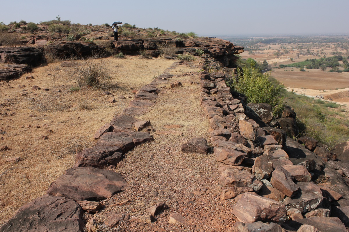
This is the northern wall. To the right is a kolla ~ narrow valley.

Looking in the direction of the tip of the spur.. we'll be heading in that direction. We climb the wall and get down..

..and come to the edge of the plateau. Near the mouth of the valley is a man-made pond to capture rain-water gushing down these slopes. A large earthen dam was constructed by the government. However  Akkargal folks felt the presence of the dam is a danger to their lands. If the dam breaks when full, water would rush straight into the lands below and wash away everything.. crops, equipment, etc. So to prevent such incidents a relief was provided at one side, that way the dam would retain water until it reached a fixed level and let out excess water.

These hill are grazing grounds for shepherds and cattle herds. In fact Banneyappa has spent many a years grazing his cattle here. These hills provided variety of berries, fruits and water. In fact we saw few seethaphal ~ custard apple trees; after a rainy season those trees will be full of fruits.

In this picture, the space between the two jutting portions is the fort entrance - that's my guess. The  passage has steps through it, partly natural and partly man-made.

As we descended into the passage, we could see shelters on both sides, they are sentry posts. Under the shelter on the left is a small platform, perhaps it was built to reduce the gap between the floor and the ceiling- that way the shelter is more effective.

On the right is a series of outcrops, they look like teeth in a canine's mouth. Malatesh and Banneyappa have already settled themselves on a rock.
Banneyappa is telling about people taking a path through this hill to Layagundi. They would walk about 5 kms one way to the market and haul back provisions for the week - that was many years ago. Now people go by buses.

Banneyappa is a kind man. He lives with his wife; God has chosen not to bless them with children.

Behind me was this formation. It has a small seat, a good spot for a sentry post. The guard can remain hidden too.

 Few centuries from now this bit of rock will give away and the formation would collapse.. i.e. if man doesn't get it before Mother Nature gets it. The break in the shade cooled us renewed our energy we made our way down. It was lunch time, Banneyappa showed us to a spot in his fields and gave us a mat to sit on. Our home packed lunch was jolada rotti, soaked cereals, salad, chatni and curds. Bannayeppa declined our invitation to join us for lunch; said he had finished lunch just before our arrival. We thanked our host, noted his address and promised to send his photo.

We saw this helipad rock formation on the other side of Akkargal hill. If it was early morning, I would have climbed up to get a closer look. It's beautiful, isn't it?

About a 3½ kms from Akkargal hill we saw this structure situated on a rocky hillock to our right. The structure seems like a temple, that can be confirmed only after a visit. Heavy quarrying activity can be seen around the hillock. I just hope the historic monuments survives as it is.

On the itinerary of the day were two more hill forts- Shantagiri and Kodathgeri. Considering the time and the distance to be traveled it may not be possible to cover both.

.........


Guledgudda fort

September 15, 2012
Guledgudda hill was blurred in Google Maps hence I wasn't sure if a fort was present there. Our inquiries in Guledgudda was futile, people had told there's no fort. The hill looked big, I did not want to spend time for nothing, we dropped Guledgudda and proceeded to Amingad fort. Few months later, the map was updated and Guledgudda fort was clearly visible.

February 23, 2013
We arrived from Katgeri, in the town entrance we found a relatively silent spot for breakfast. Upit & Uppinkai would provide sufficient energy for a steep climb. We had to enter the town and reach the eastern part of the hill, that's where the trodden uphill path was. The path was unfriendly.. we had to negotiate randomly positioned rough cut slabs and natural rock formations all the way up. With the Sun beating on our backs, the 15 minute climb left us tired but we did not stop for rest. At the edge of the plateau is a Dargah.

Dargah on Guledgudda hill.
In the above picture, the long hill is an extension of the fort hill, we did not explore that part. In the middle, on the slope is a temple dedicated to Lord Hanuman and at the tip of the hill is a watch tower. 

This is a rough plan of Guledgudda fort. 


A path behind the Dargah leads to a large half-moon shaped mound on which is the inner fort ruins. At the end of the slope on the mound is a ruined gateway, point A in the diagram. The mound's top itself is another plateau. A lone hero-stone leans against a boulder.

That's the L-shaped gateway to the inner fort. We haven't yet seen the outer fort walls, it runs along the edge of the plateau. That's Malatesh holding an umbrella to protect himself from heat. Forts are fascinating but we have to put up with little trouble.

A narrow path flanked by ruins of ancient stone structures wound its way to the white structure which would be a place of worship. At the base of that tall Neem tree is another Dargah (point D) and on the left is another gateway.

This is the view from the highest point in the core of the inner fort. The white structure is a south-facing temple (point E). What looks a heap of stones on the right is actually a circular wall, no idea what its purpose is. On a slab we saw a circular pit ½" deep. I think its man made. The point where I'm standing is close to the edge of the plateau. Fort builders have used this hill's unfriendly slopes to their advantage.

The inner fort is filled with heaps of stones formed by collapsed walls. Some of the walls are intact; this is an indication these were houses once; houses with stone walls and earthen roof held by wooden beams. This reminds me of ruins at Halsiddeshwara fort near Siddanakolla.

We moved northwards i.e. towards the edge of the mound. The mound is about 20' high at this point. Next to the rock which looks an umbrella was a path going down. We had to negotiate the slope carefully.
From the base of the rock formation, it looks like a sitting frog (point F). On seeing this rock formation we felt this hill might was ideal for settlements during prehistoric times.

We continued northwards, on the plains were these stone lines. We felt these might been field markers. Decades ago when rain was plentiful, it was possible to cultivate land and grow crops like cereals. Of course, we are not sure, these stone arrangements could mean something else too.

Now we are at the plateau edge. The rock formations seem to give a feeling this hill was inhabited during many centuries before this fort came into existence. The jutting rock looks like a mouth of a tortoise (point G).

Notice the foundation of the wall running east-west. I'm not sure if the walls were demolished or if construction was abandoned before completion. We walk along the foundation for a short distance..

..and turn 180°. If the wall stood here it would have been 4' wide. To the right is a sloping valley.

To the left we could see partially buried stone blocks. In plan this is rectangular and going by the dimension this might have been a raised platform. It is also possible this is a megalithic tomb.

There were a dozen spots with partially buried rough-cut slabs- this is an indication of megalithic dolmen. Then we found a small cairn - a stone circle.

Most of the structures here, both historic and prehistoric, seem to be sourced from these hills itself. A row if rectangular pits - sign of stone quarrying.

Walking along the northern edge we reach the north-eastern corner of the fort. A lone arch (point I) stand here surrounded by a huge heaps of stones. these heaps were once parallel walls. With little reasoning we decide this was the fort's main entrance.

A small temple near the fort entrance (point J). Notice how small the doorway is.

As we walk towards the Dargah (point A), we pass by the bastion (point K).

View of Guledgudda town from the base of the bastion.
The descent was slow because of the treacherously slippery spots. At the base of the hill we asked few locals if the name 'Guledgudda' had any meaning. No meaningful answers. We head back to the cab and ask for directions to Layagundi.. our next destination was an unknown fort 8 kms from Pattadakal on Pattadakal-Layagundi road.

.........

Mukkunda fort

March 8, 2013

This fort was on our list during Raichur-Yadgir tour but we ran out of time on that day. Today we just finished a tour of Shirguppa district of Bellary district and entered Sindhanur district to see two forts- Mukkunda and Roudkunda.

It was close to 4-30 PM when we reached Mukkunda village, the fort was visible since it stand on a rocky hillock. Its a tiny fort, one of the smallest I've seen. As drive through the village I notice two ancient temples.. could be Vijayanagara time construction.

That's the fort gateway. This is an indication of presence of a wall around hillock.

As seen from the inside, the passage is hidden from view.

We asked few people if they could show us their fort. All would tell how to go but none were willing to come. Somehow two boys- Rohit and Virupakshi -agreed to lead us. The path was filthy and stinky, the worst I'd ever experienced. Anyway, we have trained ourselves to ignore unpleasantness.

Part of the fort wall has collapsed here exposing the interior.

These rocks have steep faces, almost vertical.

The 30' climb to the top was really tricky. Without the boys help we might have struggled.

Looking to the east. This is the fort summit, a oval shaped plateau.

Looking towards west. A small shelter at the end might have been sentry barrack.

Virupakshi the boy in blue shirt slithered through a narrow gap in the rocks and reached the lower level and then clambered back to the top level.

Part of Mukkunda village.

Having seen the fort, we climbed down. this is the full length view of the fort. Lying about carelessly  are several ancient sculptures. We felt bad to see the Shiva Linga and a column with inscription (see inset).

Closer look at the inscription.

This is the inside of the gateway, I don't remember seeing this sleeping man on our way in. The boys found it funny that I was shooting a sleeping man :-)

We tanked our hosts and rushed towards Roudkunda, about 20 kms from here. I did not want to miss climbing Roudkunda hill for the second time.

.........
Older Post ►
eXTReMe Tracker
 

Copyright 2011 Journeys to temple is proudly powered by blogger.com