Tampilkan postingan dengan label tipu sultan. Tampilkan semua postingan

Huliyurdurga: Kumbi Betta and Malleswara Betta

Aug 17, 2011

My first visit to Huliyur was with Deepak and Vijay. We arrived here from Savandurga. The hill's sides are pretty steep and covered with dense vegetation. Steps are made till the Ganesha temple quarter way up. We could see painted arrows pointing the way up further. It wasn't easy, we had to do bit of circus to climb a 7 feet vertical hurdle. From there the path was barely two feet wide, it wound around the hill. The path ended and this steep rock face seemed to be the only way up. Ruins of a fort wall can be seen up the there. Climbing up is one matter but coming down will be impossible without ropes ..if not for all, it applies to me.
Deepak tried going up and gave up saying its too dangerous without ropes. He might have climbed about 12 feet, climbing down that itself was crazy. I placed my stretched arm creating a step with my palm. And the place where Vijay and I stood was barely 3 feet wide, then a steep slope.
We gave up and turned back disappointed. We were tired and we wanted to be back home before dark. As we drove out of Huliyur and turned towards Magadi, I happened to notice ruins on Hemagiri. I wanted to come back to explore it.

Aug 12, 2012

This visit Durga and Amma joined in. We left Bengaluru early, after passing Magadi we stopped for breakfast- bread, butter, cheese, jam and tomato baaji. I think it was 9 when we reached Huliyur. Hemagiri is about 2 kms from Huliyur bus-stand. Just before the hill we saw a family sowing ragi with bullocks. We stopped to inquire the route to reach the hill top. The farmers were friendly and told there are steps, climbing will not be difficult. As we spoke we noticed a pond with lotus. In the background is Hemagiri.
Bili Taavare Hoovu.
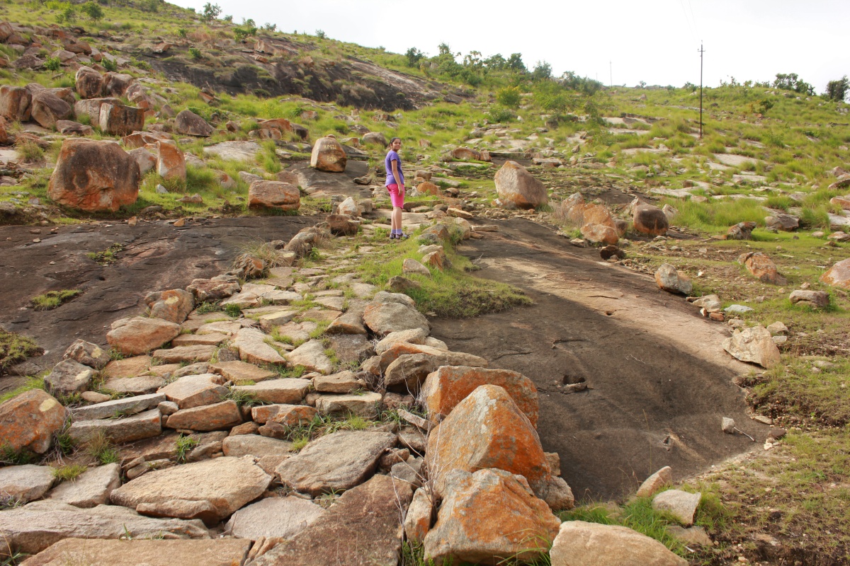
These steps look recently made; thanks to who ever took the initiative and the people who made them. That's Durga, she's really tall for her age.
The sculpted steps ended at a mantapa just behind me. We saw a dead mongoose body here. Deepak and Amma were little behind us, Durga and I were eager to reach the summit. An ancient flagstone path lies ahead..
That's Kumbi Betta and Huliyur town right next to it.
This rock formation looks like an ancient man-made shelter. Notice the small triangular pocket in the rock, on the left.
Ruins of a fort wall. We must be more than half way up now.
A small temple with beautiful Basavanna inside.
Crumbling fort walls. These walls are pretty similar to the walls on Jaalamangala hill.
Weather was pleasant, thanks to the clouds. These walls are made of rough stones, they show no signs of being dressed. In the background on the left is Kumbi Betta. Perhaps, warlords back then wanted a fort here because of higher elevation. For some reason, the fort never got completed.
Little further up, Durga and I made a model temple complex; a towering Shikhara, a Deepastambha, walls on four sides and a Dwarabagilu. We placed a small black stone in the temple- that would be a Shiva Linga and offered it nine Thumbe flowers. It was a great feeling after having made this little temple.
We are very close to the summit now. While Durga and I were busy building the temple, Amma had gone ahead. At the base of the cactus is a slab of granite, makes a very nice seat with a beautiful view.
Mallikarjuna Devasthana with a small tank opposite, no water in the tank :(

Kumbi Betta. Notice how steep the hill is.
 The fort on the top is accessible only to brave climbers.
Ruins of a fort can be seen here.
Amma had brought cucumbers, Durga passed around the peeled & cut pieces. Deepak had nicely settled on the granite slab lost in his thoughts.
I was wondering if these three lines were man-made or natural. Some youngsters had etched "Namaste Matte Banni." That's nice of them.

I climb down, not the way I came but towards the fort walls, wanted a closer look at them.
Though the climb was steep, it was comfortable because the surface of the rocks was rough, grip wasn't a problem.
I went down gradually while my company were relaxing at the top. I went past the temple we built and went further to explore the plateau extending in South direction. I noticed a group of flat topped stones lying in a tight formation ..surely they were one single rock tens of thousand of years ago.
I had signaled Durga to start climbing down. It rained few minutes, Durga and I took shelter in the mantapa while Amma and Deepak climbed down. Rain vanished as suddenly as it had appeared ..a passing rain.

Our farmer friends were still busy sowing. Even the children ran around helping the elders refill their seeds pouch. They asked us to have lunch; ragi mudde and hulli saaru. We thanked them and told our packed lunch bag was in the car, we'll have later. I gave the kinds some apples and said bye. Here's a video of the sowing activity-


Our next destination was Bairavadurga hill and Chikkanna & Thimmakka's Saalu Maragalu.

Huliyurdurga Coordinates: 12°48'45"N   77°2'54"E
.........

Koppal Fort

Some time 2003
I was traveling by bus from Hyderabad to Dharwad. On entering Karnataka, the route passed through Raichur, Koppal, Gadag.and Dharwad districts. At Raichur I got a glimpse of the fort from the bus-stand while I waited for a bus. At Koppal I was fascinated by the rocky hills. I promised to visit the town and climb the hills. Years later during my research on forts I learned about Koppal fort.

March 17, 2012

The journey from Dharwad to Koppal took about 2 hours and 30 minutes. The hill fort is visible from the main street of Koppal. Finding the way to the fort entrance was easy however driving through the narrow streets was not so easy. Anjaneya temple marked the beginning of fort area. At a street kids were curious to a car. On asking the way to fort entrance, one kid asked me if he could be a guide. That's exactly what I was looking for! Shivu was our guide at Koppal. We found a good spot to park Ravi's Indica. I asked him to stay in the car ...narrow streets, for some reason the car had to be moved.

The approach to the fort's gate at the base of the hill is filthy. I prefer not to describe it ...same problem with many of our forts. Conditions got better as we got closer to the first gateway. 

A concealed gateway Its partially damaged but overall the fort is in well preserved.
Koppala Kote
Different stages of the fort is visible from here. Looks like its a short climb to the top.
Stairway going up along the side of the hill. That's Shivu aka Shivya.
Looking back at the first gateway from the second gateway. The hillock in the picture below is a part of this fort. There's a bastion on that mound and rampart walls emerging from the bastion. To the left a water body is seen. That must be Moti Talab, a water tank just outside the fort walls.
Two flights of steps face each other. The one seen here goes up to a watch point and its a dead end.
As we emerge through the second gateway a water tank filled with green colored water is seen. There's evidence of recent restoration work carried out recently. We walk around the tank on a wide platform. In the background is the peak of this hill.
This is where a young man joined us- Mehboob. He had seen Shivu and me climbing up. His curiosity lead him here. Shivu showed me a inch diameter through hole in one of the dressed in the wall facing the town. Shivu demonstrates me how that hole was used to make a sound which could be heard at the base of this hill.
Slightly above the water tank level is another level with ruins of a mosque and two temples. One of the temples is dedicated to Yellammadevi, rituals are carried out regularly. The bastion in the mid top would be the highest point on this hill.
Looking towards the south. A watch tower can be seen in towards the bottom right. The fort was definitely well guarded. Bahadhur Banda fort is visible faintly on the horizon. When I asked Shivu and Mehboob if they can come to Bahadhur Banda. Yes!
Looking up at the bastion and the summit of this hill.
Gateway to this part of the fort is on the left. Pockets in rocks have been wisely used to store rain water. this portion has close to 5 such tanks. A trademark of Tipu Sultan. Sources say that Tipu Sultan captured Koppal fort in 1786 from Marathas. It is said that Mallasarja Desai of Kittur was imprisoned here by Tipu, however Mallasarja escapes from the prison. Koppal fort was very important to Tipu; with the help of French engineers he made it one of the strongest forts. Four years later i.e. in 1790 Tipu lost Koppal fort to British and Nizam forces. 
Very complex construction. The ditch to the right was used for capturing rain water. Notice the wall; its a dam across the gully. An inscription in Persian can be seen on the opposite wall. Mehboob's story: anyone reading the inscription will know the location of a hidden treasure but the reader's head will explode. Terrific. I assured these guys that seeking hidden treasure was not my interest.
Koppal's lake is hidden among hills. The lake's plan is three pointed. I feel this lake is a home to few migratory water birds. Breeze on this part of the hill was refreshing. At the base of the hill across the lake on the left are small cave formations. Mehboob mentioned they are used as gambling dens.
We reach the summit. The bastion offers a commanding view of the surroundings. Moti Talab is seen. To the left is the white painted stairway leading up to a Dargah. Top of this hill is supposed to be an inscription of Ashokan edicts. The inscription is called as Palaki Gundu inscription. But I wasn't sure of the location because my research showed a different location- very close to Gavimath. But Mehboob was quite confident of the location. Let's see.
The green patch in the center is the water tank on level 1. That's where Mehboob joined us. With watch points like this, surely the fort can be guarded well.
The summit bastion seen from the other side. There's another inscription on the rock face below the walls. Mehboob showed us 4 inscriptions, all Persian.
These walls were surely built during Tipu's rule. This design can be seen at Gummanayakanakote and Gudibandekote also. Notice two studs projecting out from the wall? Both studs have through holes running vertically. I asked Mehboob the purpose of those holes; flag staff is passed through them held there while the flag flies above.
One of the four inscriptions. Compared to Halegannada or Pali inscriptions definitely looks recent. The other difference is Halegannada, Pali or Marathi inscriptions are engraved but the Persian inscription here is embossed.
We spent a good deal of time. Thanks to Shivu and Mehboob- they showed me around nicely. I think Mehboob was pointing at Moti Talab.
All of us were hungry. We woke the sleeping Shivu and went in search of a canteen. We found one in the market area, it was a small one, idli was the only item on menu. Fine, we had idlis and tea. While at the canteen we asked the owner for directions for Palki Gundu. He wasn't sure, neither were to other customers. However one of them asked us to check out a hood shaped rock just behind Gavisiddeshwara Matha. We go in search of Palki Gundu...

PS: these were shot during my recent visit to Koppal.

As seen from Gavimath Gudda.
As seen from Indrakeela Betta. In the background Bahadhur Banda fort is also visible.

Koppal fort coordinates: 15°20'18"N   76°8'59"E

.........

Badami Fort

Badami Fort is spread over the hills in two parts, North and South, with the Agasthya Teertha in between. I had explored the Northern fort two times, according to a source Tipu Sultan's treasury was housed here. I had seen Southern fort long time back... during my first visit, early 80s. I cannot remember much except climbing the crazily narrow, high and steep steps. During my second visit late 90s I was disappointed to see the doorway locked. Guides told that a tourist had a fatal accident on the steps. And I ended up seeing this view during four visits.


I was determined to go up and see the fort. There has to be another way, it's such a big hill. I checked Google Maps and found a way but decided to check with locals is if anyone could guide me up.

View of both Northern and Southern parts of Badami fort.


Closer look at North fort.


The South fort- my destination.


We had reached Badami Caves by 7-15. We inquired one of the locals about the way up and a guide. Fortunately the person was encouraging... said it's not difficult to reach up, you can go on your own but would be better to take someone who nows the way around. I opted for the latter option. Soon we were introduced to a lady who in turn found the guide- Avanesh. I was skeptical if I would get along with Avanesh, he had a frown and he had woken up after a late night celebrating India's victory in the World Cup Cricket. Never mind...

Avanesh lead and I followed... first couple minutes the path was filty. Then it was fine but I got stuck at a bend, a very tricky crossing. The part of the rock had neither proper foot hold nor hand hold. To add to my dilemma, rock was slippery and a fall will end 10 feet below on a bed of thorns- Peek-Jaali-Mullu. Actually this path is often used by locals regularly and Avanesh just went around the bend as though he walked on plain land. I made Avanesh demonstrate three times and I was successful the third time. I asked him if any more circus ahead. No. The path ahead was through a cleft in the rock hill, climb was steep, over mounds of stones, had to step carefully. We might have climbed less than 10 minutes, we reached the top and the fort was in view.


Masons who built forts like this one must have been real brave characters.


The first cave is right below this wall.


The lonely cannon. You can see it's nose from down below.


Way to the steps leading down to the caves. Note how steep and narrow the stairway is. I wanted to go closer but Peek-Jaali-Mullu blocked my path. In fact the entire fort is littered with thorns. If not for the villagers gathering them, the place would be out of bounds.


The walls are well preserved but nothing inside them is left standing. to the left you can ruins... of a small palace?


Looks like a doorway to a royal home.


This part of the fort is built on the edge of a sheer cliff, two or three bastions and walls.


We were done and ready to head down. I asked Avanesh if there's anything else to see. Do you want to see old images? Yes! I imagined seeing some pre-historic paintings. Again, Avanesh lead and I followed. The view from above was great. Sun was bright but the breeze cooled me. 500m further rocks had strange shapes like inverted ice-cream bowls.


During rainy season a stream would be flowing very close where we are now. The stream would dive down the hill and flow into Agastya Threertha. The place would be stunning during rainy season.


Probably the biggest ice-cream bowl.


We must have walked a kilometer to reach this little cave temple with a neat row of standing figures, an inscription in Devanagari script, a pond of it's own and a small room. I asked for the name, Avanesh told and I forgot to make a note of it... some Theertha.

The room.


Part of the pond. Water was pretty clean but plastic a dozen bags floated in it.


Row of standing figures.


The largest figure. Is that Suryadeva? If you look below, it looks like a chariot drawn by seven horses.


The inscription in Devanagari.


The place is great, one can sit and mediate without anyone to disturb.

We had go back, Praveen and Suresh Mama did not want to join me in the climb, they were waiting at the car park. And we had to go to Aihole, I wanted to spend few hours this time... last time it was a rush, hardly saw anything. We head back towards the fort.

White building standing on the horizon are ruins of Badami Sugar Factory.


The climb down was not very difficult... only I had to choose firm stones to step on. Back at our tricky bend, I managed in one go. It was easier in this direction. I felt good. Finally I did see the fort. Thanks to Avanesh. We did get along fine :) There he is-


Later in the day, at Aihole, I learn about pre-historic rock paintings around Badami. I want to come back one day, get someone who's seen them and see them. Hope the day comes soon.

We head towards Banashankari.

.........
Older Post ►
eXTReMe Tracker
 

Copyright 2011 Journeys to temple is proudly powered by blogger.com