Tampilkan postingan dengan label forts. Tampilkan semua postingan

Nadivi fort

I stumbled on Nadivi fort while searching Wikimapia for Ashokan edicts of Nittur and Udegolam. This small fort is situated on river Tungabhadra right bank in Shirguppa taluq, Bellary district.
March 8, 2013
The road connecting Udegolam and Nadivi was pathetic but scenic. As we approached the fort, I decided to take the dirt road going left around the fort. We hit a dead end near the bastion and Ravi had to reverse his cab. Malatesh and I went by foot. I guess the fort was built some time between XV and XVII centuries.
This is the plan of Nadivi fort. Eastern and Southern walls do not exist anymore. About half the area within the fort is occupied by Ramlingeshwara temple.
I guess Nadivi fort was a sentry post for monitoring river traffic. Perhaps a sales tax check-post. Close to the base of this bastion is a shrine.
Southeastern bastion
The structure looks solid and well built. Stones seemed to be sourced from riverbed and nearby hills.

Northeastern bastion
Mortar has been used to bind the stones, that way the walls remain strong for long time. In my opinion, larger blocks make stronger walls - they withstand canon firing better than walls made of smaller stones. However downside of such forts is transporting and handling larger blocks.

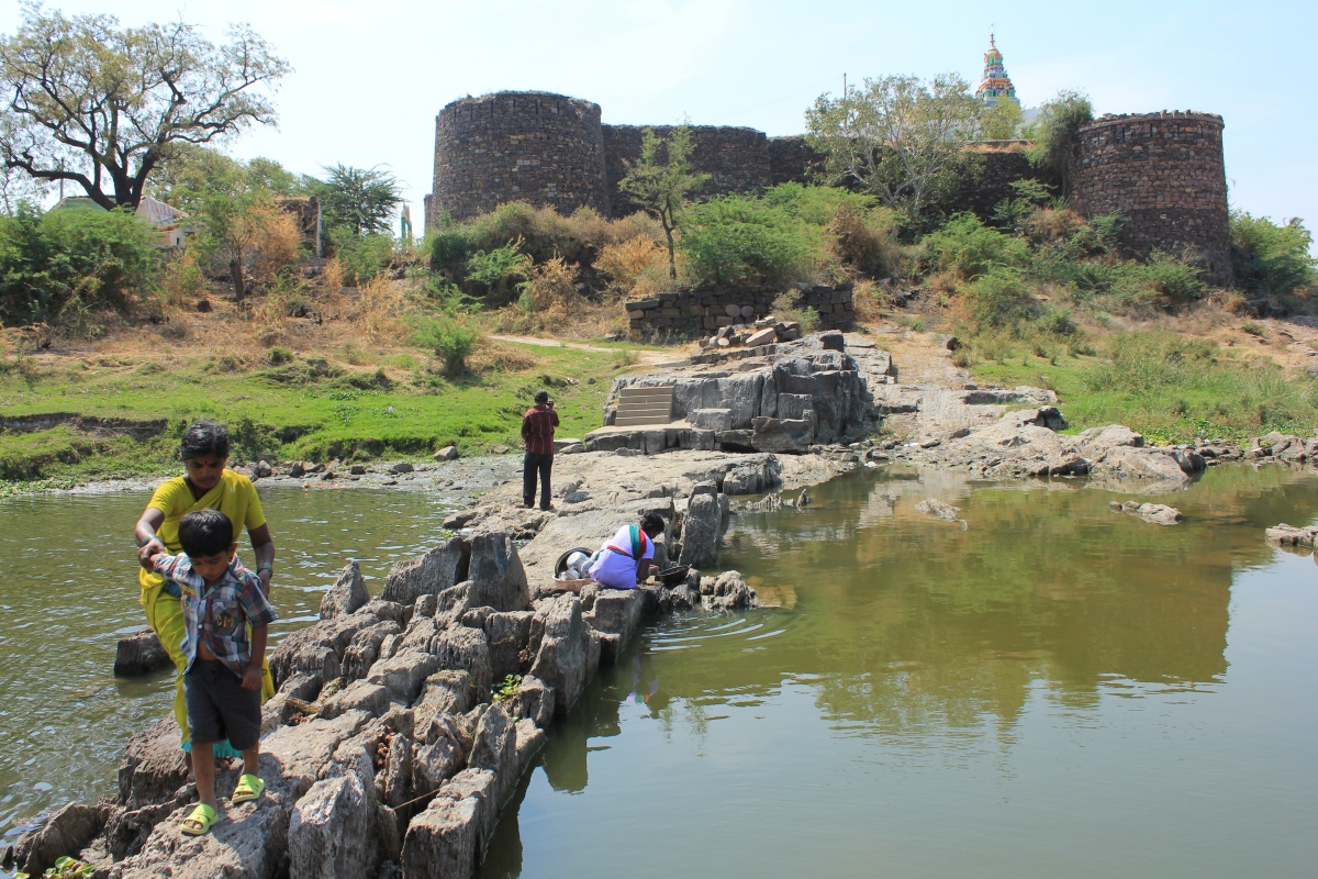
That's Ramlingeshwara temple shikhara. We did not go in since the gate was closed and there was no sign of people inside. Its a east-face temple, probably a small structure earlier. To our right flows Tungabhadra.
Blue sky reflects in the slow-flowing waters of Tungabhadra. At this point the river flows in northeast direction. Such spots are considered holy in Hindu traditions and temples are built there.

Tungabhadra flowing towards the fort, as seen from Northwestern bastion.
There's a sudden change in the river bed- a very rough patch of stones creates a hurdle. When the water level is 3' higher they remain hidden. Boat navigators sailing here must have that knowledge else the boats will get wrecked. However, when the water level is much higher, most boats can pass over easily.

Tungabhadra flowing away, as seen from Northwestern bastion.
I wonder why the wall is bent here..

Wall with right angle bend
We went on the rocks, they are really rough and some very sharp too.

Here's a short video of this river fort by Malatesh.


On the way out, an elderly person called after us. He's a priest and performs rituals at Ramlingeshwara temple. He offered us flavored water and milk. The temple fair was due soon and invited us. Very friendly person. It seems that Nadivi Ramlingeshwara temple is popular for childless couples, special poojas are performed here which help overcome problems. We thank our elderly friend and say bye.


We head towards Nittur in search of Emperor Ashoka's edict.

Nadivi fort Coordinates: 15°30'25"N   76°48'17"E

.........

Fort Tekkalakota

March 8, 2012

Tekkalakote, also known as Tekkalakota, is a small town situated 45 km north of Bellary. Within the town limits is its fort- a small simple square shaped fort with circular bastions at each of the corner. The fort's main entrance faces north direction. It also has a small doorway on the western side.

The fort is a education hub of the town, a school and a college are within the fort premises. We are standing in front of Mahadwara ~ main entrance. The colorful building on the right is a junior college. Behind me is another ancient stone wall which was built as security of Mahadwara. And on my left, out of sight, is another row of class rooms.

Mahadwara - main entrance.
I couldn't find any info about the fort on the net nor people at the town could provide any info. Hence I'll have to do a some guessing. The construction is pretty advanced, binding material is used in the walls. So this fort cannot be very old. Since this fort is located close to Hampi, it must be built during Vijayanagar times. The symmetrical floral hangs in the doorway is a typical feature in Vijayanagara architecture. 

Twin halls on raised platforms flank the gateway. Those would be security offices of the fort.

Within the walls are two small buildings, close to the south-eastern bastion. I wanted to take pictures from the building's roof, of course with permission. We spoke to a lady in-charge and learnt this is a residential school for girls, students are from nearby villages, mostly from poor families. Its a different type of school, it provides vocational training to its students besides regular academics. The schools objective is to train these youngsters to be better prepared for the outside world. Initially the lady was hesitating to let us go to the terrace, when we told her about the purpose she allowed us. It was actually convenient for Malatesh to shoot with his camcorder from the terrace.

Nearly half the area is taken by Neem tress :-) fresh cool air for students. However, view of the gateway is also obscured by the trees. In the background are the hills of Tekkalkote.

The south-eastern bastion. All bastions seem to be well preserved but the surroundings aren't so clean. I suspect the fort had a moat once..

Glimpse of the north-eastern bastion.

A peep at the side entrance. I did not want to take chances of exploring what lay beyond this gateway.

The teacher suggested us to visit Varavina Malleshwara temple near by. She told us the temple is ancient and we would surely like the place. We thanked her for the suggestion and said bye.

It was quick tour. We planned to got check out Varavina Malleshwara temple, about 4 kms east of Tekkalalote.

Recently I learnt that hills of Tekkalakote is a Neolithic site where archaeologists have discovered the foundations of circular huts and a small cemetery. While driving from Tekkalakote to Udegola we had to pass by the hills, the very look of the rock formations evoked thoughts of inhabitants on these hills. In fact I pointed out couple of rock shelters to Malatesh and told him we must check them out someday. Well, I really want to explore those hills someday.. we might see some rock paintings and prehistoric paintings are always interesting.

Tekkalakota fort co-ordinates: 15°32'4"N   76°52'50"E

.........

Shantagiri fort

February 23, 2013
It was past 4-30 PM when we arrived at Shantagiri village, with a steep slope and no path in sight the hill looked unfriendly. The climb wont be easy and this is a type of village whose folks are not quite friendly. So, I was half prepared not to find a guide. Anyway, a old man told us to take our cab as far as the water tank. Thank to his suggestion, that water tank was  ¼ way up. The remaining ¾ did not look far but the slope was pushing us backwards. To add to our problems, soil was loose and pebbles came loose under our feet. Malatesh took the lead, I was happy to be following :-)

Almost there, that''s the fort entrance.. seems like there was a gateway. Whatever gateway complex existed is in complete ruins. We had to clamber over blocks of stones to reach the end of the slope.

This how the fort is in plan. Its perched at the hill top, at a corner. The strategic location gave a commanding view of the surrounding plains and a part of hill itself. The fort's important surviving parts are 3 bastions and one well. While two of the bastions are circular and third one, the main bastion is square in plan. Of the two northern walls, left and right are about 85 meters and 117 meters long respectively.
Malatesh taking a short break and studying the view of Shantagiri village from the fort entrance.

Close to the entrance is a 3' high platform, perhaps this is the foundation of another tower. In the back ground is the western bastion. The walls are quite damaged.

We start with the western bastion.. its a turret actually. Shooting slots have been made all around. Close to the base of the structure, in the rampart wall is a narrow passage linking the inside of the fort to the moat pit on the outside. We did not spend much time here, the place had a spooky feel.

The square bastion is much taller than the bastion. At the base is a narrow door and at the top is a protrusion of a balcony. I suspect the structure was at least 8 feet taller, the upper wall has collapsed completely.

The passage is so narrow that only a slim person can enter it, that too side ways. We peeped inside, it wasn't bright but we could make out a heap of stones and remains of a stairway. Its a handsome structure. None of the neighboring forts- Belur, Wakkandurga, Kelur - has such a solid structure.

A closer view of the balcony and the plinth.

View of the fort and the moat. Notice the moat wall is lined with dressed blocks.

Rampart wall connecting central tower and the eastern bastion. Incomplete moat... the plan was to build a deep and wide moat.

Builders had designed a moat only when they were sure of availability of water. So back then water was plentiful, even on hill tops!

Ruins of a home or an office.

Now we have something interesting; a short canal connecting the moat and water tank. The rampart wall is to me back and the tank is out of view.

Here's the water tank measuring approximately 20' x 20' and 9' deep. The canal connection is on the left. It has a 3' wide platform around it and a enclosure wall with . The walls lined with black dressed blocks. At one corner is a short slight of steps to climb down into the tank when water level is low.

After seeing this water tank, I felt some of the constructions could be of Shivaji's time.

It was time to leave. We rest a while and plan our downhill route.

The climb down was quicker than expected. We still had Kodathgeri fort on our itinerary but it was too late. We decide to head back home...

.........

Akkargal fort

I had located this hill fort mid 2012 in Wikimapia and marked it as unknown fort since there was no village marked close to it. The hill was about 8 kms from Pattadakal on Pattadakal-Layagundi road. The stretch of road next to the hill ran parallel to river Malaprabha.

February 23, 2013
It was around 12-10 when we left Maliyavvana Gudi. Five minutes later we driving slowly by a hill to our right, the hill was being quarried heavily. As we drove towards the neighboring hill I saw a mile stone- Pattadakal 8 kms. Yes, the fort must be on that hill.
It was better to confirm before climbing. We saw a man in the fields, he confirmed the existence of fort on that hill. We asked if he would show us the fort.. Yes. Our friend's name is Banneyappa Kabbargi. This is half way up the hill; that's river Malaprabha and on the left bank is Banneyappa's land.

I had located the unknown fort but I forgot to ask the name. It was Malatesh who popped the question to our host. Akkargal fort was the answer.

This is a diagram of the spur of the hill on which Akkargal fort is situated. Actually the hill is quite big and the elevation of the spur is about ¾ of the summit.


The climb lasted little more than 10 minutes. This tree was the first thing came into sight, it is situated within the fort close to the south-eastern border.

Under the tree is Hanuman temple. The structure is in dilapidated condition, rituals are performed occasionally.

Within the fort are ruins of several small structures which were homes log time back. This is very similar to the ruins seen at Guledgudda fort earlier today. Some of the walls are well preserved, small cubical pockets can be seen in many. We found a grinding stone (see inset).

The plateau isn't exactly level surface, rather its a sloped surface. Within the fort is a elevated  part on which a small tower is built. Banneyappa is standing inside one of the houses. These stone-walled houses might have had earthen roofs supported by wooden beams. Banneyappa tried to identify the room; this might be a kitchen, this might be a store room, etc. We could see the houses were 2 or 3 or 4 roomed, small houses. I think back then there was no concept of bedroom, people slept in living rooms but had kitchens and store rooms.

Banneyappa said people who lived here would go down to Malaprabha river to fetch water. He must have heard this from his elders- people would hold a handful of soaked grains, the would have them while going downhill and come back with pots of water :-)

We went near the tower, the presence of fresh rubble around it confirmed it was disturbed recently. We climbed up and to our shock there was a deep pit. Definitely work of treasure seekers. We analyzed the work; a group of 15 to 20 people armed with crow bars, spades and bowls have worked through the night, mostly during a full moon. The pits base was sloping with one corner having a man sized pit- most probably the treasure was in that pit. Well, the thieves' handiwork has given us a glimpse of ancient construction methods.

View of the fort from the tower; the temple tree is sen to the left.

This is the northern wall. To the right is a kolla ~ narrow valley.

Looking in the direction of the tip of the spur.. we'll be heading in that direction. We climb the wall and get down..

..and come to the edge of the plateau. Near the mouth of the valley is a man-made pond to capture rain-water gushing down these slopes. A large earthen dam was constructed by the government. However  Akkargal folks felt the presence of the dam is a danger to their lands. If the dam breaks when full, water would rush straight into the lands below and wash away everything.. crops, equipment, etc. So to prevent such incidents a relief was provided at one side, that way the dam would retain water until it reached a fixed level and let out excess water.

These hill are grazing grounds for shepherds and cattle herds. In fact Banneyappa has spent many a years grazing his cattle here. These hills provided variety of berries, fruits and water. In fact we saw few seethaphal ~ custard apple trees; after a rainy season those trees will be full of fruits.

In this picture, the space between the two jutting portions is the fort entrance - that's my guess. The  passage has steps through it, partly natural and partly man-made.

As we descended into the passage, we could see shelters on both sides, they are sentry posts. Under the shelter on the left is a small platform, perhaps it was built to reduce the gap between the floor and the ceiling- that way the shelter is more effective.

On the right is a series of outcrops, they look like teeth in a canine's mouth. Malatesh and Banneyappa have already settled themselves on a rock.
Banneyappa is telling about people taking a path through this hill to Layagundi. They would walk about 5 kms one way to the market and haul back provisions for the week - that was many years ago. Now people go by buses.

Banneyappa is a kind man. He lives with his wife; God has chosen not to bless them with children.

Behind me was this formation. It has a small seat, a good spot for a sentry post. The guard can remain hidden too.

 Few centuries from now this bit of rock will give away and the formation would collapse.. i.e. if man doesn't get it before Mother Nature gets it. The break in the shade cooled us renewed our energy we made our way down. It was lunch time, Banneyappa showed us to a spot in his fields and gave us a mat to sit on. Our home packed lunch was jolada rotti, soaked cereals, salad, chatni and curds. Bannayeppa declined our invitation to join us for lunch; said he had finished lunch just before our arrival. We thanked our host, noted his address and promised to send his photo.

We saw this helipad rock formation on the other side of Akkargal hill. If it was early morning, I would have climbed up to get a closer look. It's beautiful, isn't it?

About a 3½ kms from Akkargal hill we saw this structure situated on a rocky hillock to our right. The structure seems like a temple, that can be confirmed only after a visit. Heavy quarrying activity can be seen around the hillock. I just hope the historic monuments survives as it is.

On the itinerary of the day were two more hill forts- Shantagiri and Kodathgeri. Considering the time and the distance to be traveled it may not be possible to cover both.

.........


Older Post ►
eXTReMe Tracker
 

Copyright 2011 Journeys to temple is proudly powered by blogger.com