Armed with a map with six forts and one ancient temple marked on it: My destinations of the day were- Belur, Wakandurga, Chikanal, Gudur, Kelur, Mangalgud, Siddankolla and Aihole. I started the journey towards Belur.
Shivu arrived with his Indica at 4-15AM, we left almost immediately. Shivu was a slow driver, used to honk unnecessarily. We were at Belur by 7-15. After a bit of struggle we got directions to the path leading up the hill. We drove through the narrow lanes towards a water tank and found a place to park the Indica.
Shivu volunteered to join me. I tried to get few local kids to guide us, none showed interest but one did come and showed us where to start the climb. The path was filthy until we reached the water-tank. The hill was quite steep, scattered with thorny bushes, fort not visible and no stairway too. We found a man and asked directions. He asked us to follow the electric poles. Simple. Loose mud, pebbles and rocks... we climbed slowly for 15 minutes to reach the summit. Going down this path is going to be tricky.
First glimpse of Belur fort wall.

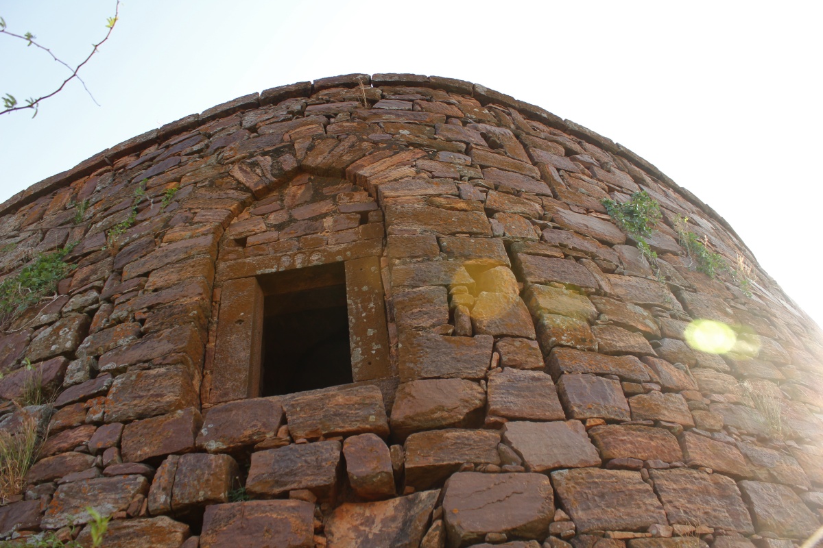
Fort temple and gateway.

Google maps grab of Belur hill. We are at point B.

A - Banashankari-Belur road
B - Fort entrance
C - Bastion and Open well
The summit is a plateau with lot of plant life; grass, thorny bushes and shrubs. The hill seems to have some wild life too, I happened to see a pair of land birds and a grey-white-brown hare. The hare was in sight for barely 2 seconds. This grass covers almost entire plateau's soil surface. I realize Shivu is not with me.

I could not make up mind to explore these ruins looks like a bastion.

As I keep walking hoping to see a large structure and I see this structure at a distance. I walk through a maze of shrubs and bushes to reach it. It looks like a bastion but its hollow inside. The only entrance to it was almost 10 feet from its base. I assume this was a specialized watch tower. Right next to it was deep pit which must have been a well, a source of water for fort staff.

I looked at the stones and gaps between them trying to calculate the risk involved in climbing up and down. Forget it, climbing down will be tricky business.

Just one small entrance, has gun holes all around it. It must have multiple uses- granary, ammunition & weapons store, emergency shelter...
I ventured a few hundred feet beyond this bastion and it became clear that I was outside the fort and was on the way to the next hill. I turn back, convinced that there's nothing more of importance here.

Once upon a time this heap of stones was a wall. Somehow I felt construction activities were abandoned in between. This is where I saw the hare, couple of leaps it was out of sight.

Neighboring hill and plains below.

This little flowering plant seem to grow out of gaps in rocks.

Other side of the ruins I passed by earlier. Built close to the southern edge of the hill this structure comprises of four bastions connected by rampart walls. It also had a elevated platform near by to provide a good view of plains below.

A cairn. This hill is a convenient place for shepherds to let their goats and sheep graze while they chat and nap in shaded spots. This cairn would be their creation. Down below are houses of Belur village.

The raised platform which served as a watch out.

I climb halfway up and lost confidence on the shaky stones I was stepping on. No sight of Shivu, no response to my calls. I guessed he must have gone back to his Indica. The climb down was not really tricky.

No sign of Shiv near the cab... there he is- walking down a narrow street. It seems he saw me climbing downhill and followed me at a distance. Sneaky!
I was hungry. Found a little eatery on the main street. The place was small, cow-dung smeared dirt floor, wooden tables and benches, run by father-son duo ...simple but clean. Menu was idli, vade and upit. We went for idli-vade, the best I had in 2011. People had no information about the fort's history. Done with breakfast, I cleared the bill and asked for directions to Gudur.
Earlier in the morning we had seen the western face of Belur hill. The eastern face as seen from Belur-Neelogal road.

My plan was to hit Gudur next but few kilometers after Hosur we happened to notice an interesting looking hill to our left. An elderly farmer told us it was Wakkandurga, "you could have gone there from Hosur itself." The farmer asked us to go to Neelogal and come back to Wakkandurga ...its not really far. If we had not run into this friend, we would have done lot of unnecessary running around. There we go to the hill fort of Wakkandurga.
Belur Fort Co-ordinates: 15°51'9"N 75°45'16"E
.........
Shivu arrived with his Indica at 4-15AM, we left almost immediately. Shivu was a slow driver, used to honk unnecessarily. We were at Belur by 7-15. After a bit of struggle we got directions to the path leading up the hill. We drove through the narrow lanes towards a water tank and found a place to park the Indica.
Shivu volunteered to join me. I tried to get few local kids to guide us, none showed interest but one did come and showed us where to start the climb. The path was filthy until we reached the water-tank. The hill was quite steep, scattered with thorny bushes, fort not visible and no stairway too. We found a man and asked directions. He asked us to follow the electric poles. Simple. Loose mud, pebbles and rocks... we climbed slowly for 15 minutes to reach the summit. Going down this path is going to be tricky.
First glimpse of Belur fort wall.

Fort temple and gateway.

Google maps grab of Belur hill. We are at point B.

A - Banashankari-Belur road
B - Fort entrance
C - Bastion and Open well
The summit is a plateau with lot of plant life; grass, thorny bushes and shrubs. The hill seems to have some wild life too, I happened to see a pair of land birds and a grey-white-brown hare. The hare was in sight for barely 2 seconds. This grass covers almost entire plateau's soil surface. I realize Shivu is not with me.

I could not make up mind to explore these ruins looks like a bastion.

As I keep walking hoping to see a large structure and I see this structure at a distance. I walk through a maze of shrubs and bushes to reach it. It looks like a bastion but its hollow inside. The only entrance to it was almost 10 feet from its base. I assume this was a specialized watch tower. Right next to it was deep pit which must have been a well, a source of water for fort staff.

I looked at the stones and gaps between them trying to calculate the risk involved in climbing up and down. Forget it, climbing down will be tricky business.
Just one small entrance, has gun holes all around it. It must have multiple uses- granary, ammunition & weapons store, emergency shelter...
I ventured a few hundred feet beyond this bastion and it became clear that I was outside the fort and was on the way to the next hill. I turn back, convinced that there's nothing more of importance here.

Once upon a time this heap of stones was a wall. Somehow I felt construction activities were abandoned in between. This is where I saw the hare, couple of leaps it was out of sight.

Neighboring hill and plains below.

This little flowering plant seem to grow out of gaps in rocks.

Other side of the ruins I passed by earlier. Built close to the southern edge of the hill this structure comprises of four bastions connected by rampart walls. It also had a elevated platform near by to provide a good view of plains below.

A cairn. This hill is a convenient place for shepherds to let their goats and sheep graze while they chat and nap in shaded spots. This cairn would be their creation. Down below are houses of Belur village.

The raised platform which served as a watch out.

I climb halfway up and lost confidence on the shaky stones I was stepping on. No sight of Shivu, no response to my calls. I guessed he must have gone back to his Indica. The climb down was not really tricky.

No sign of Shiv near the cab... there he is- walking down a narrow street. It seems he saw me climbing downhill and followed me at a distance. Sneaky!
I was hungry. Found a little eatery on the main street. The place was small, cow-dung smeared dirt floor, wooden tables and benches, run by father-son duo ...simple but clean. Menu was idli, vade and upit. We went for idli-vade, the best I had in 2011. People had no information about the fort's history. Done with breakfast, I cleared the bill and asked for directions to Gudur.
Earlier in the morning we had seen the western face of Belur hill. The eastern face as seen from Belur-Neelogal road.

My plan was to hit Gudur next but few kilometers after Hosur we happened to notice an interesting looking hill to our left. An elderly farmer told us it was Wakkandurga, "you could have gone there from Hosur itself." The farmer asked us to go to Neelogal and come back to Wakkandurga ...its not really far. If we had not run into this friend, we would have done lot of unnecessary running around. There we go to the hill fort of Wakkandurga.
Belur Fort Co-ordinates: 15°51'9"N 75°45'16"E
.........